“Since we didn’t make it to Alaska this year, let’s visit the National Parks in the Pacific Northwest!”
“Yeah, but the only time we have available is November,” answers the Lady Adventurer.
“And your point is?” is Dan’s retort to this little bit of pessimism.
After all, off-season is a good thing, not a bad thing, isn't it? Besides ... what could go wrong?
Glacier National Park
 |
| Avalanche Lake |
The adventure began by flying into Missoula, MT, and then driving a couple hours to Whitefish, near the west entrance to the park. What would have been a pretty drive north through alpine forests, mountains, and Flathead Lake was marred by low clouds, smoke, and smog. We believe the smoke was caused by prescribed burning in the area. We saw some close up on our way around the park the next day.
That next day saw a drive of several hours (around the southern border) over to St. Mary on the eastern side of Glacier National Park. Glacier is on just about everyone’s national park bucket list for good reason: it’s spectacularly beautiful. By our reckoning, the park lives up to that reputation. The scenery is wonderful.
 |
| St. Mary Lake |
 |
| One of the higher mountains viewed from the Red Eagle trail |
The weather helped. Going in November would be iffy at best, and downright dangerous at worst. But for one thing, we don’t like crowds (and there weren’t many this off-season), and for another, this late fall timeframe just worked best for us. As expected, several park roads were closed for the season, including the famous Going to the Sun Road. Although we wouldn’t be able to see much of the park, the parts we did manage to get to were grand. This day, the sun danced with the clouds, and it was quite beautiful. We only had rain on the way back – it appeared to have stayed west of the Continental Divide.
We managed to get a couple hikes in: part of the Red Eagle trail in St. Mary, and the short Running
Eagle Falls loop in Two Medicine.
 |
| Two Medicine Falls |
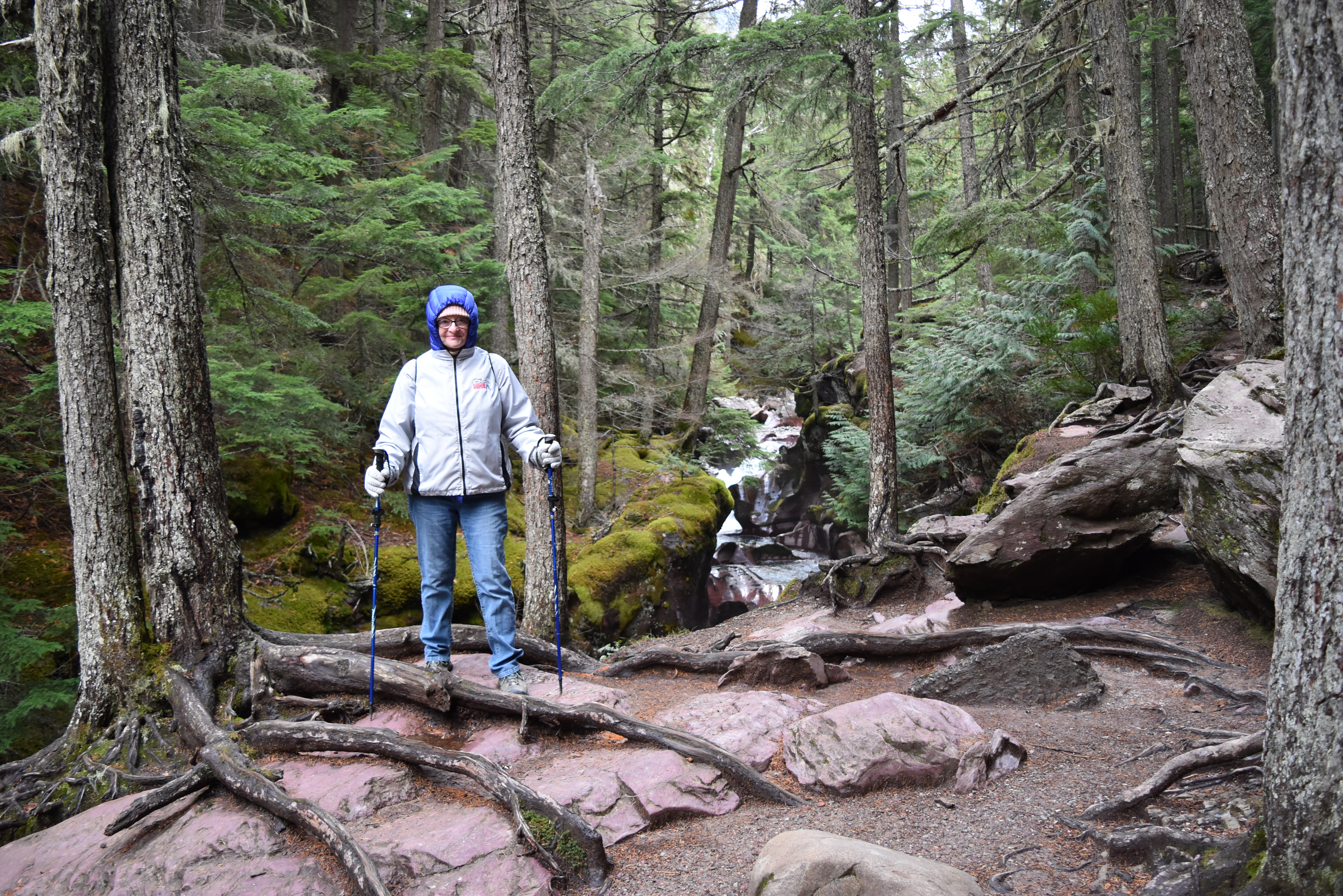
From the popular western entrance at West Glacier, we were able to drive on Going to the Sun Road as far as Avalanche (about 15 miles). Once there, we hiked the Trail of the Cedars and the Avalanche Lake Trail. Even though it was long and moderately difficult, it was all pretty epic. Avalanche Lake itself is spectacular, with sheer walls of the surrounding waterfall-strewn mountains topped by glaciers. Lady Adventurer and Old Gimpy really enjoyed it.
 |
| Trail of the Cedars |
 |
| Falls along the Avalanche Lake Trail |
 |
| Avalanche Lake |
Whitefish is pretty cool. Besides its proximity to the park, it’s also the home of nearby Whitefish ski resort. There’s a nice little downtown area with shops, bars, and restaurants. November, being between summer and winter ski season, is about as off-season as you can get so the town was quiet, but once again, that was fine with us.
Glacier National Park lives up to its reputation. It’s especially nice off-season.
North Cascades National Park
Although this park is relatively close to Seattle, it is still quite remote, difficult to get to, and seldom visited. We made it over to Concrete, just west of the park, in a little under ten eventful hours. Said eventfulness included outstanding beauty in western Montana, a massive snowstorm in Idaho, torrential rain in parts of Idaho and Washington, moments of serene sunshine in Eastern and Central Washington, more heavy snow near Snoqualmie Pass in Washington, more rain and sunshine around Seattle, and a stunning sunset-facing storms along with a bright rainbow in the mountains as we got near Concrete. Good thing we took the long way to stay on the interstate rather than the more treacherous route through the Cascades.
 |
| Approaching Concrete |
The Cascades Mountain Suites – Mount Baker Hotel was closed for the season. Fortunately, they made an exception for us since we’d made the reservation much earlier. They left our keys in a lockbox and we never saw another human anywhere near the place. We did manage to find a couple restaurants that also weren’t shut for the season. Even a winery.
We only did some short hikes in the park: the Gorge Overlook Trail and Trail of the Cedars, among others. Note that every park is required to have at least one Trail of the Cedars. It was all fine, but we would have done more if it hadn’t been raining. The rain at our lower elevation equated to snow higher up. Lots of snow. This weather made the spectacular scenery ever more awesome and enjoyable, although blue skies and sunshine would have been welcome as well.
 |
| Near the West entrance to North Cascades NP |
 |
| Great mountains everywhere with snow at the higher elevations |
 |
| Diablo Lake Overlook |
 |
| Ross Lake |
There are sheer cliffs and mountains that surround you at every turn. There are also three dams that create beautiful lakes but otherwise mar the scenery with transmission lines for the hydroelectric power being sent to Seattle.
During the short drive from the park back to Concrete, we stopped at Glacier Peak Winery. It’s in an unexpected, but spectacular location, and it’s excellent.
North Cascades National Park, although not as well-known as some, is still the favorite of many. It’s now ours as well.
Olympic National Park
Finding the Hurricane Ridge area closed due to snow was unexpected, but we enjoyed our time on the Northside of the park nonetheless. We hiked the Heart o the Forest Trail in the Heart o the Hills area. The forest walk was primeval, quiet, serene, and fairly awesome. To see this part of the park, we stayed in Sequim, which required a ferry along with a couple hours of driving. We dined on superb seafood at Kokopelli’s Grill in Port Angeles.
 |
| Heart o the Forest Hike |
 |
| View of Port Angeles from Olympic NP |
From there, we drove around the Olympic Peninsula to Olympia, which is south of the park. Along the way, we stopped at Lake Crescent, the Hoh Rainforest, and Ruby Beach.
Due to rain and construction, we were only able to make a brief stop at Lake Crescent. That was a little sad; it’s a beautiful area.
 |
| Lake Crescent |
“When you get out of the car to hike, it will look just like it does now, except you will be getting soaked.” We’d been approaching the Hoh Rainforest area in a driving rainstorm, while discussing possible hikes. Lady A., whom I will temporarily refer to as Lady SA (for Lady SmartAss), let her feelings be known about hiking in the drenching rain. I wound up using our only umbrella and going at it alone on the outstanding Hall of Mosses Trail. Just when we thought things couldn’t get any greener, there’s this great section of the park. And what better way to see the foremost temperate rain forest than during a constant, steady rain?
 |
| Hoh Rain Forest Hall of Mosses Trail |
The rain miraculously stopped for the time we spent at Ruby Beach. The sun even came out for a few minutes. But then the rain began all over again. We were lucky to be there at the right time.
 |
| Ruby Beach |
 |
| Ruby Beach |
Olympic National Park has outstanding temperate rain forest sections, fantastic beaches, and snow-capped mountains. It’s also huge. We could have spent more time here. Especially if the rain would go away.
Mount Rainier National Park
“Do you have your tire chains?” It sounded like something my friend asked on multiple occasions when she learned of our November travels. I think it was just to rattle my cage a little. But this time, it wasn’t her at all. It was the Mount Rainier National Park Ranger at the entrance station. And my cage was definitely being rattled, because she was dead serious. Even though we had our National Parks passes, we would ALSO need the tire chains before we’d be allowed to enter the park. Furthermore, the park road was closed past the Longmire area. We wouldn’t be making it to Paradise this day.
Remember the rain we encountered the day before? Up here, it fell as snow, and lots of it. Lady A. wanted to just take off and perhaps find someplace where we could just view the great mountain. I nearly concurred, but just for the heck of it, we drove six miles out to Ashford and, as it turned out, wound up renting tire chains, turning around, and heading back in.
Thank goodness, we didn’t need to use the chains. This day was bright and sunny, and the snow, at least at the lower elevations, was melting. The snow and water dropping from the trees was interesting and fun. We even managed to get a short hike in through the deep snow on the Trail of the Shadows.
 |
| Mount Rainier |
 |
| Other surrounding mountains seen on the trail |
Based on the outstanding and spectacular sights of the snow everywhere, Mount Rainier and the surrounding mountains were as beautiful as any we’ve seen.
The Oregon Coast
“Isn’t enough enough?” The plan had been to drive nearly the entire length of the Oregon Coast, starting in Astoria, and then cutting over to the interior past Coos Bay. But the rain was ridiculous. It was of biblical proportions, and as much as we tried to enjoy the sights and sounds of this otherwise wonderful seascape, it was impossible. We cut over to I5 much earlier than planned and took the faster route to Grant’s Pass, our home for the night and our launchpad for Crater Lake National Park the next day.
 |
| The Oregon Coast (in the rain) |
But wait. By the time we got to Grant’s Pass, the rain had stopped (at least in these parts), and the sun even came out a little. We enjoyed the surprisingly lively little town, and also visited a couple of the local wineries: Schmidt Family Winery and Troon Vineyards. We didn’t hesitate to inform the latter establishment that we actually lived on Troon Avenue. But I don’t think they were impressed.
 |
| Troon Vineyard |
 |
| Another Vineyard Pic |
So, after the disappointing morning (since we didn’t get to enjoy the coast) we had a very nice late afternoon and evening in town and at the wineries.
Crater Lake National Park
The drive from Grants Pass to Crater Lake National Park was wonderful. Southwestern Oregon is absolutely beautiful. But as we approached the park, we started seeing more and more snow on the sides of the road. This is not to mention the snow-recreation areas and the chain-up sections. It was beginning to seem like a rerun of our Mount Rainier experience. Therefore, we emitted a joint sigh of relief when the gatehouse guard let us in without asking about chains, since there was no place to rent them this time. The relatively warm temperatures and pleasant sunshine were working in our favor this day.
 |
| Crater Lake |
 |
| Crater Lake and the surrounding mountains |
 |
| Crater Lake |
 |
| Crater Lake |
Crater Lake is spectacular, especially when surrounded by snowy hills and mountains. Unfortunately, we weren’t able to hike very far in the deep snow. Instead, we just walked around Rim Village and took pictures. It was also unfortunate that we weren’t able to drive along the western coast up to the North Entrance; we had to go the long way around in order to drive up to Eugene. This part of the drive was beautiful as well.
Silver Falls State Park and Columbia River Gorge
“How ‘bout I bend you over the bathtub and just pour water over your head?” Lady SA was at it again, remarking about all the waterfalls we’re seeing. “Suck it up, Lady,” I say. We’re gonna do a bazillion falls today.
Located between Eugene and Portland, Silver Falls State Park is a real gem. There are ten major waterfalls in the park, and many more minor ones. We hiked for three difficult but rewarding miles and saw four or so of the falls. The Maple Ridge and Canyon trails were covered with water themselves, so the footing was bad. It was especially so when walking behind some of the falls.
 |
| Hiking Silver Falls |
 |
| Hiking Silver Falls |
 |
| Hiking Silver Falls |
From there, we drove up to the Columbia River Gorge, where Multnomah Falls is one of the main attractions. It’s amazing. It’s the second-highest year-round waterfall in the U.S. The bridge partway up makes it a cool sight. We were lucky that it was only a short walk from the parking area; we were beat from the Silver Falls hike.
 |
| Multnomah Falls |
We also stopped and walked around at Turkey Rock State Park and at Lewis and Clark State Recreation Area.
 |
| Columbia River |
The exploration of the Columbia River Gorge continued with visits to Larch Mountain, where we couldn't see two feet in front of us due to the heavy rain, and Wildwood Recreation site, where the lower elevation afforded nice weather and scenery just an hour later. We got to watch Chinook Salmon swimming upstream. That was cool! And it was also the end of our adventure.
...
To sum it all up:
3,000 road miles on the rental car (and this time we've cleaned the interior before returning it)
5 National Parks
6 State Parks
1 National Forest that we hiked, and several others that we drove through
2 near-missed collisions with large animals
Bazillions of waterfalls
Too much rain and a bit much snow for comfort
1 rental of tire chains